Dengler Images

  • Portfolio
    • Portfolio Book
    • Sample Images
  • Archive
  • Blog
  • Store
    • Licensing
    • Prints
    • Note cards
    • Books
  • About
    • Bio
    • Services
    • Newsletter Signup
    • Instagram
    • Copyright
    • Privacy Policy
  • Contact

Glacier Bay’s enormity is hard to fathom (video)

January 21, 2023 by John L. Dengler

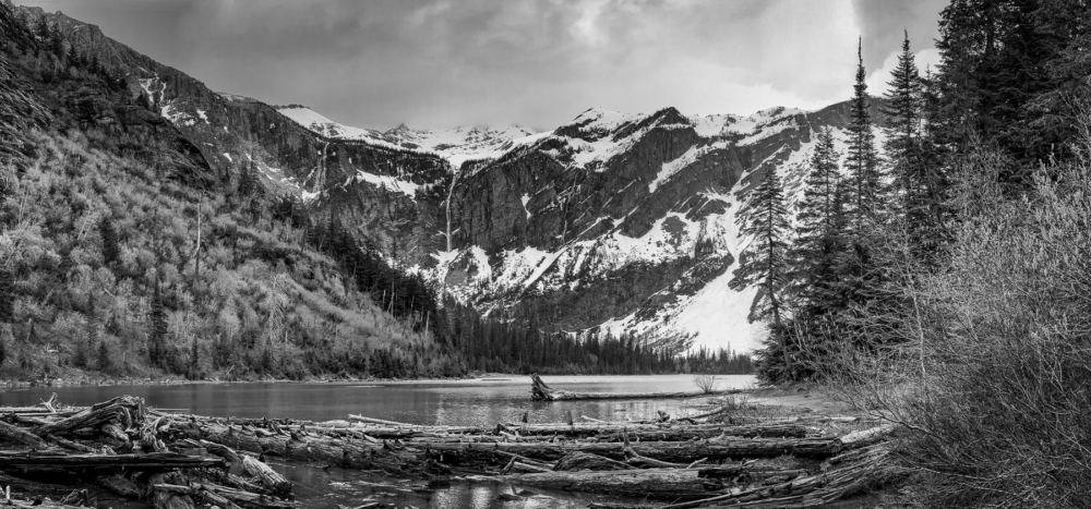
The main bay of Glacier Bay National Park and Preserve in Southeast Alaska is vast, stretching 69 miles from its mouth to the furthest extent. It is hard to imagine that the area shown (a small portion of the bay) was a single large glacier of solid ice only a little over 200 years ago.

In the mid-1700s, this view (and quite a bit beyond) would have been covered by a glacier nearly a mile in thickness. Since then, the massive glacier that filled the bay has retreated 69 miles to the heads of various inlets. Recent research determined that there is 11% less glacial ice in Glacier Bay than in the 1950s. Still, even with the earth’s rapidly changing climate, Glacier Bay is home to a few stable glaciers due to heavy snowfall in the nearby Fairweather Mountains.

The pictured view is of the Beartrack Mountains looking from Tlingit Point to North Marble Island and South Marble Island.

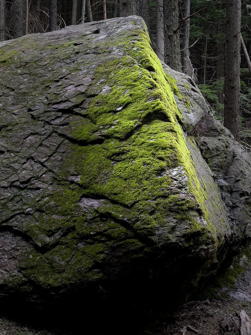
The park is an important marine wilderness area known for its spectacular tidewater glaciers, icefields, and tall coastal mountains. A popular destination for cruise ships, the park is also known for its sea kayaking and wildlife viewing opportunities. Glacier Bay National Park is home to humpback whales, which feed in the park’s protected waters during the summer, both black and grizzly bears, moose, wolves, sea otters, harbor seals, Steller sea lions, and numerous species of sea birds. The dynamically changing park, known for its large, contiguous, intact ecosystems, is a United Nations biosphere reserve and a UNESCO World Heritage site.

Editors note: The video is a panoramic composite of several overlapping still images.

LINKS

  • BLOG POST: Wet adventures in Glacier Bay National Park
  • BLOG POST: Glacier Bay National Park – Witnessing change
  • BLOG POST: Massive landslide pours onto Lamplugh Glacier
  • BLOG POST: Glacier Bay images published by Alaska Geographic
  • PHOTO GALLERY of images of Glacier Bay National Park and Preserve
  • PHOTO GALLERY of the Lamplugh Glacier landslide

To see our collection of fine art prints, click here

Capturing memories of Glacier National Park with a cell phone camera

June 19, 2022 by John L. Dengler

While I spent most of a recent long-weekend trip to Glacier National Park in Montana lugging my heavy Nikon camera and lenses, I found myself without them during an impromptu hike to Avalanche Lake in the park. 

The point I want to make is that it has been said that the best camera is the camera you have with you. In this case, all I had was my iPhone. Not having my super high-quality Nikon equipment forced me to approach photography differently. The best part was not being burdened by lugging the typical backpack of gear up the mountain. Being liberated from this made the hike enjoyable and allowed me to easily and quickly try different things.

It really is true. The best camera is the camera that you have with you. Would I have taken more technically better quality photos with my Nikon equipment? Probably, but without the iPhone on this hike on this day, I would have only had memories had I not had the phone.

The 4.5-mile roundtrip hike to the mountain lake was fun, relatively easy, with beautiful scenery. Included that day was a side-hike through a grove of giant western cedars on the Trail of the Cedars trail that connects with the Avalanche Lake Trail.

Western Red Cedar branch litter
Twigs and small branches litter the forest floor under a giant western red cedar tree (Thuja plicata) along the Trail of the Cedars, a wheelchair-accessible trail in Glacier National Park.
Western Red Cedar tree
One of the huge western red cedar trees along the Trail of the Cedars, a wheelchair-accessible trail, in Glacier National Park. The humidity of the Lake McDonald Valley enables the cedars to grow in size of 100 feet tall and diameters of four to seven feet, with many of the trees being more than 500 years old. The western red cedar is one of the most widespread trees in the Pacific Northwest, ranging from southern Alaska to northern California. This grove in Glacier National Park is near the eastern terminus of the western red cedar range.
Forest view of Trail of the Cedars
The Trail of the Cedars, a wheelchair-accessible Glacier National Park trail, allows visitors entry to the magical world of a 500-year-old western red cedar / black cottonwood forest.
Black cottonwood tree
In this photo, a black cottonwood tree (Populus balsamifera), foreground, is bathed in the dappled light of the forest. The fuzzy fruit of the tree floats in the air during the spring and early summer, creating the look of warm-season snow. They inhabit riparian areas, including streams. 
Avalanche Creek gorge
Both the Trail of the Cedars and the Avalanche Lake Trail afford incredible views of the gorge of Avalanche Creek. This photo was taken very near where the easy Trail of the Cedars joins the more moderate-challenging Avalanche Lake Trail.
Avalanche Creek
Avalanche Creek overflows onto the forest floor along the 4.5-mile roundtrip hike to Avalanche Lake.
Moss covered boulder
A sliver of sunlight lights a moss-covered boulder—an excellent example of how photography is all about light.
Avalanche Lake
Rain approaches Avalanche Lake as seen from the Avalanche Lake Trail. Avalanche Lake was named in 1895 by a party including Dr. Lyman Sperry, namesake of the Sperry Glacier, who witnessed many avalanches during their stay. The meltwater from Sperry Glacier feeds the lake. Monument Falls can be seen cascading down the mountain in the background along the cliff face. Avalanche Lake is the destination of the 4.5-mile roundtrip Avalanche Lake Trail. This photo was taken with the iPhone panorama shooting feature.

Glacier National Park in the Rocky Mountains of Montana encompasses more than 1 million acres. The park’s nickname is the “Crown of the Continent Ecosystem.” The park was established in May 1910. Soon after, hotels and chalets were established in the park, including the Lake McDonald Lodge. In 1932 construction began on the Going-to-the-Sun Road, allowing automobiles to traverse the park. Climate change is affecting the park. As of 2010, only 25 active glaciers remain in the park, down from the 150 that existed in the mid-19th century.


Be the first to know ‘Follow’ Dengler Images on Instagram @DenglerImages or follow my Twitter feed to know when I post iPhone reports from the field.

Call the “High One” Denali, not Mt. McKinley

February 6, 2015 by John L. Dengler

Sun rises on Mount McKinley and the Alaska Range as seen from Wonder Lake in Denali National Park and Preserve in Alaska. Mount McKinley also known as Denali is North America's tallest peak at 20,320 feet and towers over 18,000 feet above the surrounding lowlands. Other mountain peaks pictured include: Mount Brooks, Mount Silverthrone, Mount Tatum, and Mount Carpe. SPECIAL NOTE: This image is a panorama composite consisting of multiple overlapping images stitched together. (John L. Dengler)

UPDATE: On August 31, 2015, President Obama put the issue to rest and changed Mt. McKinley to Denali.

Yesterday’s news that Alaska Republican U.S. Sens. Lisa Murkowski and Dan Sullivan are making the annual introduction of a bill to officially rename 20,310-foot Mt. McKinley to it’s original historical Athabaskan name, Denali (the Great One or the High One), reminded me of how privileged and lucky I have been to have seen and photograph the mountain. If you ever are lucky enough to see Denali, I think you will understand why I side with Alaskans on this issue. Words and pictures can never describe the view. There literally isn’t a mountain visually taller on the planet. Even though Mt. Everest is higher, Denali’s 18,000-foot change in elevation from it’s base in the lowlands to it’s peak is more than Mt. Everest (only a 12,000-foot change).

Photo Gallery

Images from Denali National Park and Preserve

I’ll never forget the first time I saw Denali, North America’s tallest peak, on our first visit to Wonder Lake, located deep in Denali National Park and Preserve. After a 6-hour, 84-mile bus ride in a modified school bus, we arrived at Wonder Lake in light rain. Denali is only 25 miles away from Wonder Lake but it was totally obscured by clouds. Not seeing the mountain for weeks, or even a month at a time, isn’t unusual. A visitor has a 33-percent chance of seeing the mountain with clear skies. The odds of a partial view aren’t much better at 40-percent. The park rangers at the Eielson Visitor Center, the closest park visitor center to the peak in the park, keep a calendar in which they hand draw what the peak looked like on a particular day. Most of the drawings are gray clouds.

Mt. McKinley, also known as Denali (Athabaskan for "The High One") basks in morning light at sunrise in Denali National Park and Preserve in Alaska. The snow and glacier covered mountain, part of the Alaska Range soars to a height of 20,320 feet. Mt. McKinley is the tallest mountain on the North American continent. Although Mt. Everest is higher, the vertical rise of Mt. McKinley is greater. This view is a small detail from the north slopes of the mountain seen from Wonder Lake. (John L. Dengler)

Denali basks in morning light at sunrise in Denali National Park and Preserve. This view is a small detail from the north slopes of the mountain seen from Wonder Lake.

So you can imagine we were dang excited when later that evening we saw a sliver of the mountain in the still heavily overcast skies. Impressed, I took a few photos and went to bed. Then in the early dawn at roughly 4 a.m., Carol shook me telling me I had to immediately get up and look outside the tent. My jaw dropped. The sliver of the mountain that we had seen the night before, was only the foothills of the peak. Those mountains looked like the familiar mountains of the Front Range in Colorado. Towering above them was the icy granite massif, Denali. Even at a distance of 26 miles away we had to tilt our heads upward to take in the mountain. Next to seeing the Aurora borealis, it is probably the most spectacular thing I have seen.

I hope that anyone who makes the effort to Denali National Park gets a chance to see the mountain. Here are some tips that might increase your chances. First, the Wonder Lake campground is the closest you can get to the mountain on land without serious backpacking across the dangerous swift moving McKinley River. It is a great backcountry campground located in a wet boggy area and is one of the most mosquito infested places I have been. Only camping in the Everglades in the summer was worse. You won’t think anything of the cold, rainy, and fierce mosquitos if you get to see the mountain. If you don’t see the mountain, you might curse me for ever putting the thought of seeing the mountain in your head. To increase your chances, you’ll want to stay multiple days at Wonder Lake. I usually try to stay 4 – 6 days, using Wonder Lake as a base to day hike from. The park’s shuttle bus makes it easy to day hike in other areas of the park once you have explored the Wonder Lake area on foot. The final tip I would give is to get up early. It has been my experience that Denali is often visible in the very early morning hours. Don’t hit the snooze alarm though. More often than not it might only stay completely clear for 20 minutes. The mountain creates its own weather and it changes quickly.

Denali teased me in my failed attempt take this time-lapse movie of the clouds swirling around the peak overnight. I hoped that it would eventually clear in this view from Wonder Lake. No such luck.

There is no question that Denali has been over-photographed by professional and amateur photographers. That still doesn’t deter me from trying. Just the exercise of putting in extra effort to simply see the mountain makes it worthwhile. Frankly, in many ways, trying to photograph the mountain is futile. Seeing Denali is one of those things you have to see in person. A photograph will never capture the immensity and majesty that you experience in person.

So as the Alaska delegation tries again after four and a half decades of previous attempts to get the mountain renamed, I’m hoping that this time they succeed and defeat the Ohio delegation’s (President William McKinley was from Ohio) attempts to block the name change to Denali, the name it was for thousands of years before a gold prospector called the mountain McKinley.

Sun rises on Mount McKinley and the Alaska Range as seen from Wonder Lake in Denali National Park and Preserve in Alaska. Also pictured is the setting moon, above Mount McKinley. Mount McKinley also known as Denali is North America's tallest peak at 20,320 feet and towers over 18,000 feet above the surrounding lowlands. Other mountain peaks pictured include: Mount Brooks, Mount Silverthrone, Mount Tatum, Mount Carpe and Mount Foraker. SPECIAL NOTE: This image is a panorama composite consisting of multiple overlapping images stitched together. (John L. Dengler)

ABOVE: Sun rises on Denali and the Alaska Range as seen from Wonder Lake in Denali National Park and Preserve. Also pictured is the setting moon, above Denali. Other mountain peaks pictured include: Mount Brooks, Mount Silverthrone, Mount Tatum, Mount Carpe and Mount Foraker. EDITORS NOTE: This image is a panorama composite consisting of multiple overlapping images stitched together.

TOP OF PAGE: Sun rises on Denali and the Alaska Range as seen from Wonder Lake in Denali National Park and Preserve. EDITORS NOTE: This image is a panorama composite consisting of multiple overlapping images stitched together.

LINKS

  • DENALI NATIONAL PARK – Park Guides The park’s newspaper is an excellent source of information about the park including how to plan your visit.
  • NATIONAL PARK SERVICE, Official Denali National Park and Preserve website

To license image, click image. To see our collection of fine art prints, click here.

Nugget Falls – a lesson of scale in Alaska

August 21, 2014 by John L. Dengler

Hikers to Nugget Falls located next to the Mendenhall Glacier near Juneau, Alaska are dwarfed by the 377 foot waterfall. Each year, 465,000 curise ship passengers visit the Mendenhall Glacier. (John L. Dengler)

Scale is an important concept to grasp in Alaska. Things are big, really big — actually bigger than big. However, scale in Alaska is also not what it appears to be.

My introduction to this phenomenona goes back over 15 years ago when my wife Carol and I made our first backpack trip in Denali National Park. In preparation for the trip I poured over topographic maps to plan our multi-day backcountry trip into a part of the park where there are no trails. I carefully formulated a route over rivers and through the mountains. That carefully crafted route went out the window when we arrived to the area. You see, topographic maps in Alaska are at a different scale. In the lower 48, topographic contour intervals on maps are 20 feet. On Alaska maps, the contour interval is 100 feet. The small river bank that I thought was only 20 feet was actually a steep 100 foot high wall. Hills turned out to be mountains. Scale in Alaska was painfully learned on that trip. Lesson learned.

Photo Gallery

Images from Juneau, Alaska

Flash forward a dozen or more years where I’m now aware of what I call ‘Alaska scale’. I now know that in order to help viewers of my work appreciate just how big things are in Alaska, I need to give context and clues to the scale of the subject of the photograph.

My recent post about the publication of one of my Mendenhall Glacier photos reminded me of one of my favorite photos, taken at the glacier. On one of my trips to the Mendenhall Glacier I photographed the powerful Nugget Falls of Nugget Creek as it drops down into Mendenhall Lake near the face of the glacier. Including people in the image helps give a sense of scale. The falls look (and are) HUGE!

Wait I say, not so fast. Remember my first lesson about “Alaska scale”? That same general principle applies to this photo. Things are not what they seem in Alaska.

See the tiny waterfall in the image below. That’s Nugget Falls, the same falls in the image above. In the greater scheme of the landscape at Mendenhall Glacier the falls are quite small. This scale phenomenon is one of things I find so intriguing about Alaska.

An iceberg floats in Mendenhall Lake located at the terminus of the Mendenhall Glacier. Also reflected in the lake is Bullard Mountain and Nugget Falls. The glacier runs roughly 12 miles, originating in the Juneau Icefield, near Juneau, Alaska. The glacier is located 12 miles from downtown Juneau. Each year, 465,000 curise ship passengers visit the Mendenhall Glacier. (John L. Dengler)

ABOVE: An iceberg floats in Mendenhall Lake located at the terminus of the Mendenhall Glacier. Also reflected in the lake is Bullard Mountain and Nugget Falls. The glacier runs roughly 12 miles, originating in the Juneau Icefield, near Juneau, Alaska. The glacier is located 12 miles from downtown Juneau. Each year, 465,000 curise ship passengers visit the Mendenhall Glacier.


To license image, click image. To see our collection of fine art prints, click here.

« Previous Page
Next Page »

Search this blog

Follow Me

  • Email
  • Facebook
  • Instagram
  • RSS
  • Vimeo

Recent Dispatches

  • Recent landslide-triggered tsunami brings back memories
  • Nature’s Window: Snowy, quiet day in Haines
  • Channeling Bradford Washburn
  • Haines Winterfest equals winter fun
  • Prairie chicken photos published by North American Grouse Partnership
  • Springtime at Devil’s Den
  • Sharp-tailed grouse video published by Audubon Magazine
  • Black and White – only because I felt like it

Blog Category Topics

  • Books
  • Environment
  • Fauna
  • Featured
  • Fine art prints
  • Flora
  • Gear
  • iPhone Field Reports
  • Landscapes
  • Latest Dispatches
  • Note cards
  • Passions
  • Personal
  • Photojournalism
  • Recreation
  • Research
  • Sports
  • Tearsheets
  • Techniques
  • Travel
  • Videos
  • Wildlife

New archive images

Gallery of new outdoor photos added to photo archive

Contact

Phone:
+1.417.849.5642
Email:
studio@denglerimages.com

Copyright Information

All photographs and text within DenglerImages.com are copyright John L. Dengler and/or the stated publication and are presented for web browser viewing only. Nothing contained within this site may be reproduced, downloaded, stored, copied, manipulated, altered, or used in any form without prior written permission from John L. Dengler and/or the stated publication. Do not "pin" images on pinning sites (Pinterest, Tumblr, etc.). Using any image as the base for another illustration or graphic content, including photography, is a violation of copyright and intellectual property laws. Violation of copyright will be actively prosecuted.

Newsletter signup

Sign up for our free email newsletter to keep updated on recent work, new products, or coupon specials. Simply enter your details, and confirm your address with the confirmation email that we send. It's easy and safe. We never share our newsletter list.

CLICK HERE to sign-up to receive newsletter and new blog post alerts.

Dengler Images, LLC specializes in stock image licensing of photos of wildlife, nature, landscape,
outdoor sports and recreation, travel, and our environment.

© 2008-2025 John L. Dengler, Dengler Images, LLC - All rights reserved.