Dengler Images

  • Portfolio
    • Portfolio Book
    • Sample Images
  • Archive
  • Blog
  • Store
    • Licensing
    • Prints
    • Note cards
    • Books
  • About
    • Bio
    • Services
    • Newsletter Signup
    • Instagram
    • Copyright
    • Privacy Policy
  • Contact

Channeling Bradford Washburn

February 22, 2024 by John L. Dengler

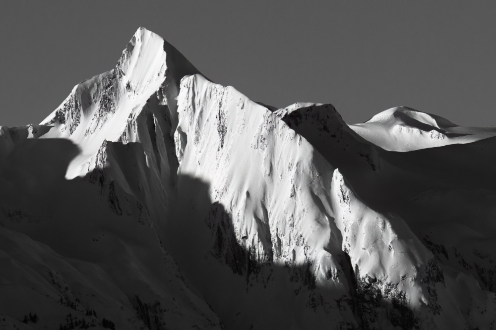
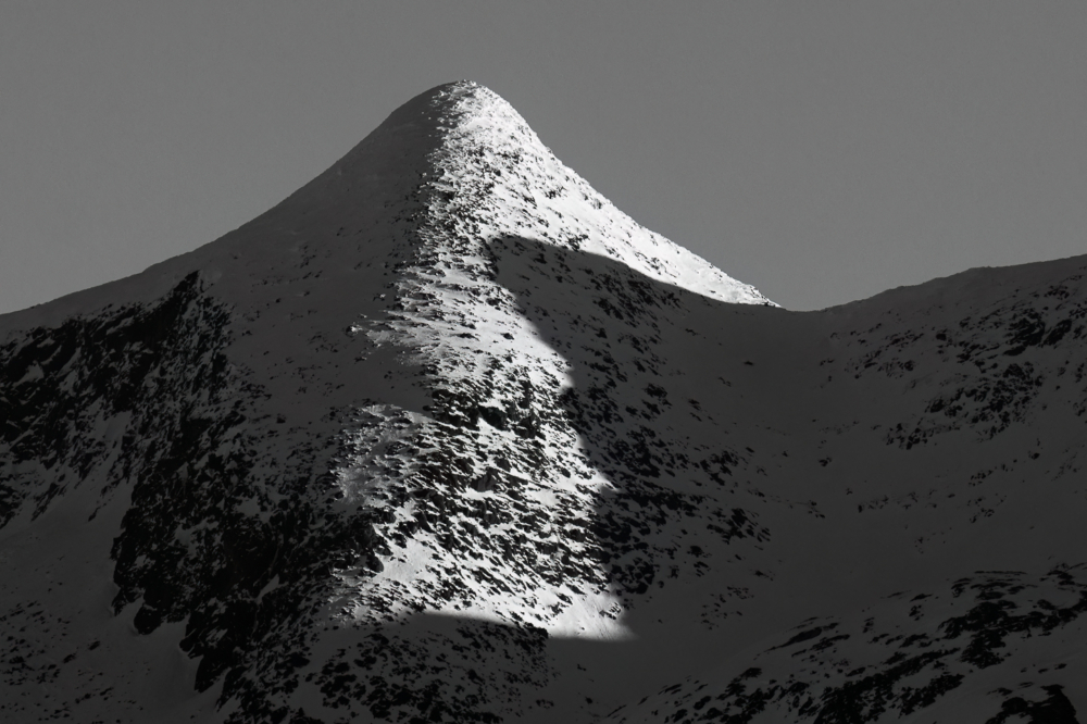
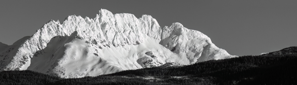
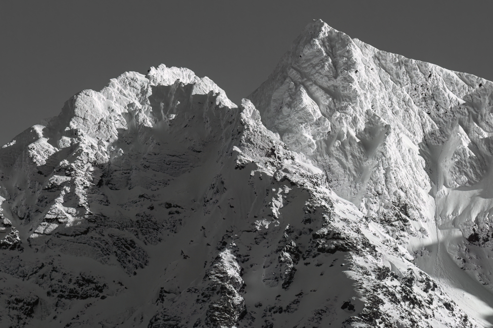
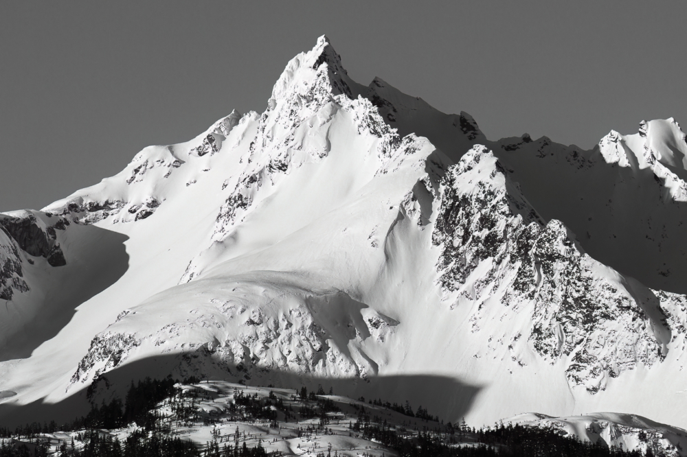
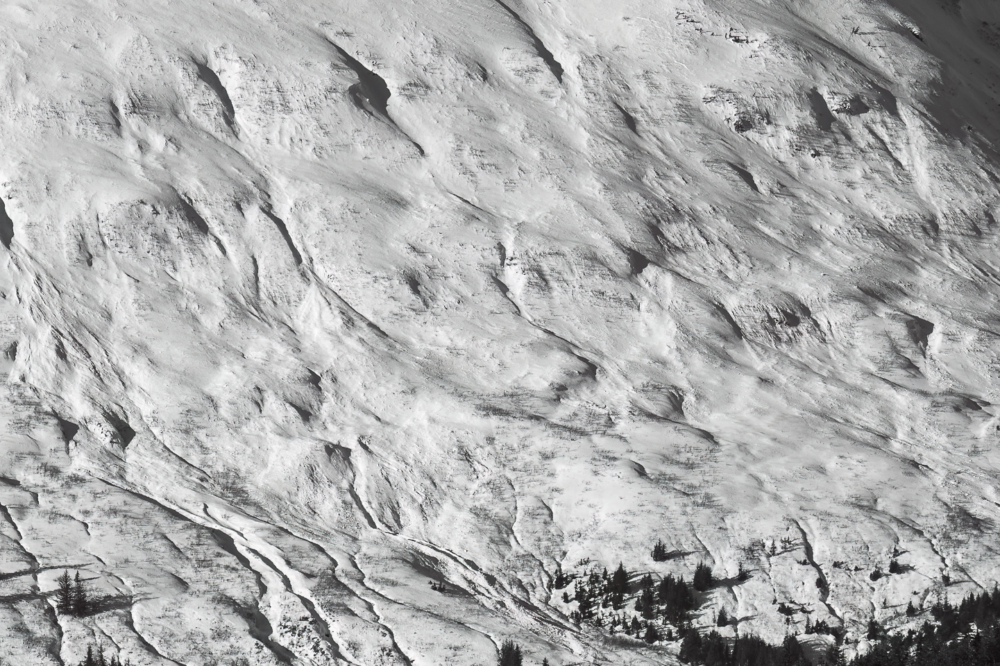
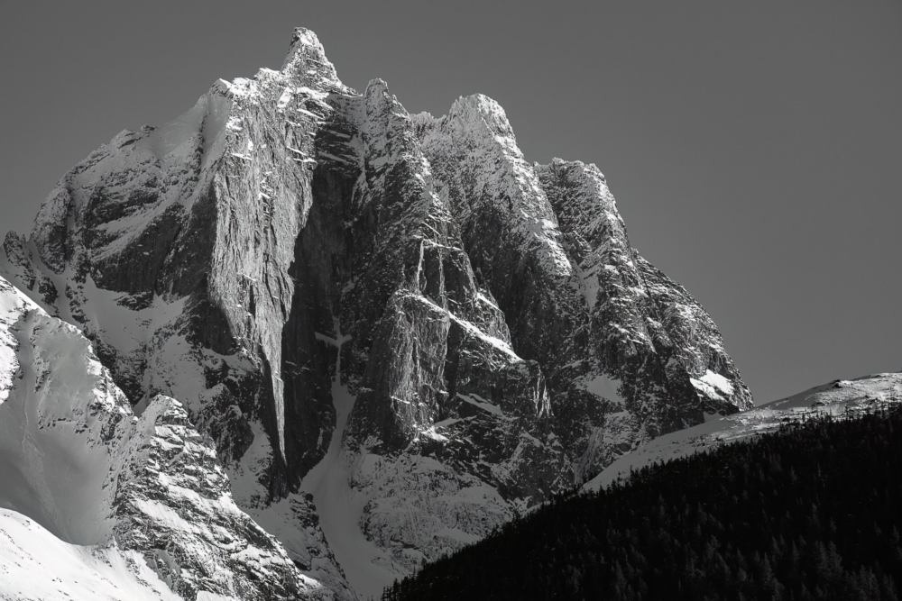
I channeled my inner Bradford Washburn (a famous Alaska mountaineer and photographer known for his dramatic black-and-white photography) on a spectacular clear day last week while riding the ferry from Juneau to Haines, Alaska.

 It is very hard to get a sense of the scale of the magnificent mountains and glaciers that line the edge of the Lynn Canal, the 90-mile long, 2,000-foot deep fjord that runs from Juneau to Skagway. If you look very closely at some of the photos, you will see tiny trees that are, in reality, huge.

Much of Washburn’s photography resulted from his quest to find routes and create maps for many of his first assent Alaska mountain climbs. While I won’t pretend that my photos below come anywhere near Washburn’s, the stark, simple, yet detailed look is perhaps somewhat similar. I can still kick myself because before he died in 2007, prints of his work could be purchased somewhat reasonably. Not surprisingly, today, that is not the case.

Unidentified mountain peaks along the Lynn Canal as seen from the Alaska Marine Highway ferry, M/V Hubbard as it traveled from Juneau to Haines on a bright winter day.
Nun Mountain (4329′) is seen from the Alaska Marine Highway ferry M/V Hubbard as it traveled in the Lynn Canal from Juneau to Haines on a bright winter day.
Unidentified mountain peak along the Lynn Canal as seen from the Alaska Marine Highway ferry, M/V Hubbard as it traveled from Juneau to Haines on a bright winter day.
Unidentified peak as seen from the Alaska Marine Highway ferry M/V Hubbard as it traveled in the Lynn Canal.
Unidentified mountain peaks along the Lynn Canal as seen from the Alaska Marine Highway ferry, M/V Hubbard as it traveled from Juneau to Haines on a bright winter day.
During the winter, with snow on its steep mountainside, it is easier to see how Lions Head Mountain got its name.
Unidentified mountain peaks along the Lynn Canal as seen from the Alaska Marine Highway ferry, M/V Hubbard as it traveled from Juneau to Haines on a bright winter day.
Unidentified peak as seen from the Alaska Marine Highway ferry M/V Hubbard as it traveled in the Lynn Canal.
Unidentified mountain peak along the Lynn Canal as seen from the Alaska Marine Highway ferry, M/V Hubbard as it traveled from Juneau to Haines on a bright winter day.
Huge trees look like tiny sticks compared to the unidentified mountain of the Chilkat Range, as seen along the Lynn Canal during the ferry ride from Juneau to Haines.
Mountain slope along the Lynn Canal as seen from the Alaska Marine Highway ferry, M/V Hubbard as it traveled from Juneau to Haines on a bright winter day.
Detail of a mountain slope of the Chilkat Range. Note the size of the trees at the lower right.
Unidentified mountain peaks along the Lynn Canal as seen from the Alaska Marine Highway ferry, M/V Hubbard as it traveled from Juneau to Haines on a bright winter day.
An unnamed mountain peak near Sinclair Mountain, as seen from the Alaska Marine Highway ferry traveling from Juneau to Haines in February.

LINKS:

  • PHOTO GALLERY: Haines, Alaska
  • PHOTO GALLERY: Juneau, Alaska

The Juneau Road – a road to somewhere or nowhere?

November 29, 2014 by John L. Dengler

This sign marks the end of the Glacier Highway that currently ends at Echo Cove, approximately 43 miles north of Juneau, Alaska. The Juneau Access Improvements Project is a proposed $570-million road project to extend Glacier Highway for closer access to the southeast Alaska towns of Haines and Skagway. Juneau, Alaska’s capital, is the only capital city in the United States whose roads do not connect with the continental road network. Currently travelers either have to fly between Juneau, Haines and Skagway, or travel on one of the Alaska Marine Highway System ferries. The plan by Alaska’s Department of Transportation and Public Facilities calls for extending the road 48 miles along the Lynn Canal from Echo Cove north of Juneau to the Katzehin River where a new ferry terminal would be built. From there yet-to-be-built smaller ferries would transport vehicles and passengers to Haines and Skagway with four to eight trips per day. The proposal, decades in the making, is a contentious issue within the Lynn Canal communities. Proponents cite greater travel flexibility, lower costs for the state and travelers. Opponents cite concerns for marine and terrestrial wildlife, economic loss to local businesses, winter travel safety, landscape degradation, lack of planning for handling walk-on passengers to and from the remote Katzehin terminal and the high cost of the project. Most of the $570-million road construction cost will be paid by the federal government, with the state picking up approximately 10 percent in matching costs. (© John L. Dengler/Dengler Images)

The Juneau Access Improvements Project is a proposed $570-million road project to extend Glacier Highway out of Juneau for closer road access to the southeast Alaska towns of Haines and Skagway. Juneau, Alaska’s capital, is the only capital city in the United States whose roads do not connect with the continental road network. Currently travelers either have to fly between Juneau, Haines and Skagway, or travel on one of the ferries of the Alaska Marine Highway System.

Photo Gallery

Construction a concern for Gran Point Steller sea lions

The plan by Alaska’s Department of Transportation and Public Facilities calls for extending the road 48 miles along the Lynn Canal from its current dead end at Echo Cove north of Juneau (pictured above) to the Katzehin River where a new ferry terminal would be built. From there yet-to-be-built smaller ferries would transport vehicles and passengers to Haines and Skagway with four to eight trips per day.

According to the Associated Press, most of the $570-million road construction cost will be paid by the federal government, with the state picking up approximately 10 percent in matching costs.

The proposal, decades in the making, is a contentious issue within the Lynn Canal communities.

Proponents make their case

Proponents say that the road will give greater flexibility to travelers, make travel cheaper, faster. According to the Alaska Department of Transportation’s 2014 Juneau Access Improvements Project: Draft Supplemental Environmental Impact Statement, travel time with the new highway and shorter ferry runs would be reduced travel. The report used these examples.

Current total travel time by ferry (including check-in time, loading and unloading, in-transit, and driving):

Auke Bay (Juneau) to Haines: 7.2 hours (mainline ferry), 4.0 hours (fast ferry)
Auke Bay (Juneau) to Skagway: 9.1 hours (mainline ferry), 4.1 hours (fast ferry)

If a direct highway connection existed (at 40-50 miles per hour) the department of transportation estimates these travel times:

Auke Bay to Haines: 1.5 – 2 hours*
Auke Bay to Skagway: 2 – 2.5 hours*

*does not include ferry travel time to/from the proposed Katzehin ferry terminal and related staging/waiting time for the shuttle ferry

Proponents also suggest that extending the current highway will free up resources to improve ferry service to other parts of southeast Alaska by moving the larger ferries currently used and replacing those ferries with smaller ferries that would run shorter distances more frequently.

Opponents speak out

The proposed highway is not without opponents. During public comment meetings in Haines, Skagway and Juneau, most speakers were opposed to the plan. Reasons cited include difficult and costly construction across steep faces that the road would travel, 41 active avalanche chutes, and over 100 identified land and rock slide areas. Also a concern is the degradation of the world-class scenery due to the highway being rock cut much of the way spoiling views popular with cruise ship passengers, economic loss for small businesses in Haines and Skagway due to better access to Juneau businesses, and general winter safety travel concerns. Some speakers at the public comment meetings were skeptical of the figures for traffic demand for the road. They also expressed concern on how to handle walk-on passengers for the short ferry trips between Haines/Skagway and the proposed unmanned Katzehin ferry terminal. The concern is that travel would become more expensive and difficult for walk-aboard ferry passengers. It is unclear how walk-aboard ferry passengers would secure ground transportation from the proposed remote Katzehin Ferry terminal to Juneau, approximately 90 miles away.

Conservation concerns

Conservation and environmental groups are concerned about potential impacts on marine and terrestrial wildlife. Concerns include increased animal mortality from vehicle collisions and easier hunter/trapper access, habitat fragmentation by wildlife that typically avoid roads and impact on bald eagle nests. Another concern is for the Steller sea lions (Eumetopias jubatus) who frequent the Met Point and Gran Point haulouts.

Among the concerns related to the proposed Juneau Access Improvements Project is the Steller sea lion haulout at Gran Point (pictured). The haulout at Gran Point is a designated Steller sea lion Critical Habitat Area. According to the Alaska Department of Transportation’s 2014 Juneau Access Improvements Project: Draft Supplementary Environmental Impact Statement, more than one hundred Steller sea lions (Eumetopias jubatus) have been counted at the haulout during the spring and fall. As currently proposed the proposed highway would be built just uphill from the haulout area, approximately 100 to 600 feet horizontally and 50 to 100 feet vertically. Highway plans near the haulout includes blasting steep rock-cut embankments and several tunnels with one tunnel entrance only 550 feet away from the haulout. There is concern for haulout abandonment by the sea lions during highway construction as studies have shown Steller sea lions are very sensitive to noise, both in and out of water. Because Steller sea lions frequent Gran Point nearly year round, the use of explosives and helicopters will be challenging during construction. There are two distinct populations of Steller sea lions in Alaska. The majority of Stellar sea lions that frequent the Lynn Canal are part of the eastern population of Steller sea lions which are not listed as endangered under the Endangered Species Act; unlike the western population of Steller sea lions which are listed as endangered. That said however, there have been confirmed sightings of the western population Steller sea lions at Gran Point. The Juneau Access Improvements Project is a proposed $570-million highway project to extend Glacier Highway out of Juneau for closer road access to the southeast Alaska towns of Haines and Skagway. Juneau’s roads do not connect with the continental road network. Editors note: This is a cropped version of image# I00007z0NNeMhXeA (John L. Dengler)

Of particular concern is the haulout at Gran Point, a designated Steller sea lion Critical Habitat Area (pictured above and below). According to the supplementary Environmental Impact Statement, more than one hundred Steller sea lions have been counted at the haulout during the spring and fall. As currently proposed the proposed highway would be built just uphill from the haulout area, approximately 100 to 600 feet horizontally and 50 to 100 feet vertically.

Among the concerns related to the proposed Juneau Access Improvements Project is the Steller sea lion haulout at Gran Point (pictured). The haulout at Gran Point is a designated Steller sea lion Critical Habitat Area. According to the Alaska Department of Transportation’s 2014 Juneau Access Improvements Project: Draft Supplementary Environmental Impact Statement, more than one hundred Steller sea lions (Eumetopias jubatus) have been counted at the haulout during the spring and fall. As currently proposed the proposed highway would be built just uphill from the haulout area, approximately 100 to 600 feet horizontally and 50 to 100 feet vertically. Highway plans near the haulout includes blasting steep rock-cut embankments and several tunnels with one tunnel entrance only 550 feet away from the haulout. There is concern for haulout abandonment by the sea lions during highway construction as studies have shown Steller sea lions are very sensitive to noise, both in and out of water. Because Steller sea lions frequent Gran Point nearly year round, the use of explosives and helicopters will be challenging during construction. There are two distinct populations of Steller sea lions in Alaska. The majority of Stellar sea lions that frequent the Lynn Canal are part of the eastern population of Steller sea lions which are not listed as endangered under the Endangered Species Act; unlike the western population of Steller sea lions which are listed as endangered. That said however, there have been confirmed sightings of the western population Steller sea lions at Gran Point. The Juneau Access Improvements Project is a proposed $570-million highway project to extend Glacier Highway out of Juneau for closer road access to the southeast Alaska towns of Haines and Skagway. Juneau’s roads do not connect with the continental road network. Travelers either have to fly between Juneau, Haines and Skagway, or travel on one of the ferries of the Alaska Marine Highway System. (John L. Dengler)

Highway plans near the haulout includes blasting steep rock-cut embankments and several tunnels with one tunnel entrance only 550 feet away from the haulout. There is concern for haulout abandonment by the sea lions during highway construction as studies have shown Steller sea lions are very sensitive to noise, both in and out of water. It was originally believed that construction could take part during a one to five week period when the haulout was unused by the Steller sea lions. New studies, and remote camera monitoring have shown that Steller sea lions now frequent Gran Point nearly year round making the use of explosives and helicopters more challenging.

Among the concerns related to the proposed Juneau Access Improvements Project is the Steller sea lion haulout at Gran Point (pictured). The haulout at Gran Point is a designated Steller sea lion Critical Habitat Area. According to the Alaska Department of Transportation’s 2014 Juneau Access Improvements Project: Draft Supplementary Environmental Impact Statement, more than one hundred Steller sea lions (Eumetopias jubatus) have been counted at the haulout during the spring and fall. As currently proposed the proposed highway would be built just uphill from the haulout area, approximately 100 to 600 feet horizontally and 50 to 100 feet vertically. Highway plans near the haulout includes blasting steep rock-cut embankments and several tunnels with one tunnel entrance only 550 feet away from the haulout. There is concern for haulout abandonment by the sea lions during highway construction as studies have shown Steller sea lions are very sensitive to noise, both in and out of water. Because Steller sea lions frequent Gran Point nearly year round, the use of explosives and helicopters will be challenging during construction. There are two distinct populations of Steller sea lions in Alaska. The majority of Stellar sea lions that frequent the Lynn Canal are part of the eastern population of Steller sea lions which are not listed as endangered under the Endangered Species Act; unlike the western population of Steller sea lions which are listed as endangered. That said however, there have been confirmed sightings of the western population Steller sea lions at Gran Point. The Juneau Access Improvements Project is a proposed $570-million highway project to extend Glacier Highway out of Juneau for closer road access to the southeast Alaska towns of Haines and Skagway. Juneau’s roads do not connect with the continental road network. Travelers either have to fly between Juneau, Haines and Skagway, or travel on one of the ferries of the Alaska Marine Highway System. (John L. Dengler)

There are two distinct populations of Steller sea lions in Alaska. The majority of Stellar sea lions that frequent the Lynn Canal are part of the eastern population of Steller sea lions which are not listed as endangered under the Endangered Species Act; unlike the western population of Steller sea lions which are listed as endangered. That said however, there have been confirmed sightings of the western population Steller sea lions at Gran Point.

What’s next?

Public comments on the project are now closed. The Alaska Department of Transportation and Public Facilities expects to release their final supplemental Environmental Impact Statement in 2015.

Update: New spending on project halted

In January of 2015, Alaska Gov. Bill Walker issued an order stopping new spending on this project. He questions whether the state can afford such a project with oil prices falling.


LINKS

  • JUNEAU ACCESS IMPROVEMENT PROJECT – Alaska Department of Transportation and Public Facilities
  • 2014 DRAFT SUPPLEMENTARY ENVIRONMENTAL IMPACT STATEMENT (large file, 28 MB)
  • BLUE HIGHWAY –  a 22-minute documentary film that explores the issue
  • LYNN CANAL CONSERVATION
  • SOUTHEAST ALASKA CONSERVATION COUNCIL

To license image, click image. To see our collection of fine art prints, click here.

Nugget Falls – a lesson of scale in Alaska

August 21, 2014 by John L. Dengler

Hikers to Nugget Falls located next to the Mendenhall Glacier near Juneau, Alaska are dwarfed by the 377 foot waterfall. Each year, 465,000 curise ship passengers visit the Mendenhall Glacier. (John L. Dengler)

Scale is an important concept to grasp in Alaska. Things are big, really big — actually bigger than big. However, scale in Alaska is also not what it appears to be.

My introduction to this phenomenona goes back over 15 years ago when my wife Carol and I made our first backpack trip in Denali National Park. In preparation for the trip I poured over topographic maps to plan our multi-day backcountry trip into a part of the park where there are no trails. I carefully formulated a route over rivers and through the mountains. That carefully crafted route went out the window when we arrived to the area. You see, topographic maps in Alaska are at a different scale. In the lower 48, topographic contour intervals on maps are 20 feet. On Alaska maps, the contour interval is 100 feet. The small river bank that I thought was only 20 feet was actually a steep 100 foot high wall. Hills turned out to be mountains. Scale in Alaska was painfully learned on that trip. Lesson learned.

Photo Gallery

Images from Juneau, Alaska

Flash forward a dozen or more years where I’m now aware of what I call ‘Alaska scale’. I now know that in order to help viewers of my work appreciate just how big things are in Alaska, I need to give context and clues to the scale of the subject of the photograph.

My recent post about the publication of one of my Mendenhall Glacier photos reminded me of one of my favorite photos, taken at the glacier. On one of my trips to the Mendenhall Glacier I photographed the powerful Nugget Falls of Nugget Creek as it drops down into Mendenhall Lake near the face of the glacier. Including people in the image helps give a sense of scale. The falls look (and are) HUGE!

Wait I say, not so fast. Remember my first lesson about “Alaska scale”? That same general principle applies to this photo. Things are not what they seem in Alaska.

See the tiny waterfall in the image below. That’s Nugget Falls, the same falls in the image above. In the greater scheme of the landscape at Mendenhall Glacier the falls are quite small. This scale phenomenon is one of things I find so intriguing about Alaska.

An iceberg floats in Mendenhall Lake located at the terminus of the Mendenhall Glacier. Also reflected in the lake is Bullard Mountain and Nugget Falls. The glacier runs roughly 12 miles, originating in the Juneau Icefield, near Juneau, Alaska. The glacier is located 12 miles from downtown Juneau. Each year, 465,000 curise ship passengers visit the Mendenhall Glacier. (John L. Dengler)

ABOVE: An iceberg floats in Mendenhall Lake located at the terminus of the Mendenhall Glacier. Also reflected in the lake is Bullard Mountain and Nugget Falls. The glacier runs roughly 12 miles, originating in the Juneau Icefield, near Juneau, Alaska. The glacier is located 12 miles from downtown Juneau. Each year, 465,000 curise ship passengers visit the Mendenhall Glacier.


To license image, click image. To see our collection of fine art prints, click here.

Mendenhall Glacier photo published in Alaska magazine

August 17, 2014 by John L. Dengler

Tearsheet from the Sept., 2014 edition of Alaska magazine showing tourists at the Mendenhall GlacierI scored another tearsheet from Alaska “The magazine of Life on the Last Frontier” with the publication of one of my images of tourists visiting the Mendenhall Glacier. The image is nicely displayed as a full page image in the September, 2014 issue. The publication of the image even generated a congratulatory phone call from someone besides my late grandmother who actually read the tiny photo credits.

Previous tearsheet from Alaska magazine

Bald eagles fighting image published in Alaska magazine

The photo was taken on one of my Juneau layover days while waiting for the Alaska Marine Highway Ferry for Haines. I always make it a point to head out to the nearby Mendenhall Glacier for a hike and to take photographs. I’m never disappointed no matter what the weather. My favorite activity is to hike the easy to intermediate level trails that lead from either the Mendenhall Glacier Visitor Center or from the parking lot on the west side of Mendenhall Lake. You’ll quickly find solitude on the trails once you leave the visitor center area as most of the herd of cruise ship passengers walk out to Photo Point (seen in the photo) or hike the short trail to Nugget Falls. Mendenhall Glacier is a popular spot for cruise ship passengers. It sees over 500,000 visitors a year.

As I have mentioned previously, Alaska magazine, features great photography and stories on the people, cultures, lifestyles, and natural wonders of the state. The magazine can often be found at local bookstores and newsstands. Electronic editions/subscriptions of Alaska magazine for the iPad can be found on the Apple iTunes App Store.


Be the first to know
‘Like’ the Dengler Images Facebook page
or follow my Twitter feed
to know when I post iPhone reports from the field.

Next Page »

Search this blog

Follow Me

  • Email
  • Facebook
  • Instagram
  • RSS
  • Vimeo

Recent Dispatches

  • Recent landslide-triggered tsunami brings back memories
  • Nature’s Window: Snowy, quiet day in Haines
  • Channeling Bradford Washburn
  • Haines Winterfest equals winter fun
  • Prairie chicken photos published by North American Grouse Partnership
  • Springtime at Devil’s Den
  • Sharp-tailed grouse video published by Audubon Magazine
  • Black and White – only because I felt like it

Blog Category Topics

  • Books
  • Environment
  • Fauna
  • Featured
  • Fine art prints
  • Flora
  • Gear
  • iPhone Field Reports
  • Landscapes
  • Latest Dispatches
  • Note cards
  • Passions
  • Personal
  • Photojournalism
  • Recreation
  • Research
  • Sports
  • Tearsheets
  • Techniques
  • Travel
  • Videos
  • Wildlife

New archive images

Gallery of new outdoor photos added to photo archive

Contact

Phone:
+1.417.849.5642
Email:
studio@denglerimages.com

Copyright Information

All photographs and text within DenglerImages.com are copyright John L. Dengler and/or the stated publication and are presented for web browser viewing only. Nothing contained within this site may be reproduced, downloaded, stored, copied, manipulated, altered, or used in any form without prior written permission from John L. Dengler and/or the stated publication. Do not "pin" images on pinning sites (Pinterest, Tumblr, etc.). Using any image as the base for another illustration or graphic content, including photography, is a violation of copyright and intellectual property laws. Violation of copyright will be actively prosecuted.

Newsletter signup

Sign up for our free email newsletter to keep updated on recent work, new products, or coupon specials. Simply enter your details, and confirm your address with the confirmation email that we send. It's easy and safe. We never share our newsletter list.

CLICK HERE to sign-up to receive newsletter and new blog post alerts.

Dengler Images, LLC specializes in stock image licensing of photos of wildlife, nature, landscape,
outdoor sports and recreation, travel, and our environment.

© 2008-2025 John L. Dengler, Dengler Images, LLC - All rights reserved.