Dengler Images

  • Portfolio
    • Portfolio Book
    • Sample Images
  • Archive
  • Blog
  • Store
    • Licensing
    • Prints
    • Note cards
    • Books
  • About
    • Bio
    • Services
    • Newsletter Signup
    • Instagram
    • Copyright
    • Privacy Policy
  • Contact

Breaking the ice at Mendenhall Glacier

October 28, 2013 by John L. Dengler

The Mendenhall Glacier runs roughly 12 miles, originating in the Juneau Icefield, near Juneau, Alaska. This photo of the glacier was taken on the Trail of Time. The glacier is located 12 miles from downtown Juneau. (John L. Dengler)

When I start a trip I always feel a bit unsettled, but once I’ve taken a photo or two that somewhat pleases me, I become relaxed and the creative juices start to flow. This “breaking the ice” can never come soon enough.

Photo Gallery

Images from Juneau

So on my current trip to film bald eagles on the Chilkat River near Haines, Alaska, the first thing I did upon landing in Juneau was to head to the nearby Mendenhall Glacier to stretch my weary airplane legs and “break the ice” by shooting some still images.

Being one of the most visited tourist attractions in Alaska, the Mendenhall Glacier is a frantic place during the summer cruise ship season. That’s not the case during the fall when you practically have the area to yourself. I headed to the visitor center overlooking Mendenhall Lake and the glacier beyond.

An enthusiastic U.S. Forest Service employee greeted me and asked if I would want her to start up the center’s new film about the nearby icefields and Tongass National Forest. I did and within a few minutes I was joined in the visitor center theater by miniature dinosaurs, dragons, bats, and other little “monsters” who were visiting for a special Halloween weekend of interpretive activities on bats. The costumed kids were just as mesmerized as I was with the sights in the film.

Seeing the film with its excellent photography just made more anxious to get my creative mojo going. Out the door I went and started on the very easy and short “Trail of Time”,

In the past I have never given this trail a thought because visitor center that is next to the trailhead and withall the cruise ship visitors flowing in andout it is a very congested area. . What a mistake, the trail’s interpretive wayside signs talk about the glacier retreat which is evident through the change of rocks, soil, and vegetation as you hike farther from the glacier. You can also see the remains of man’s imprint on the area; such as the rusting pipe that once delivered water to the now long gone Steep Creek Powerhouse.

This steel pipe built between 1912 and 1914 once carried water over one mile from Nugget Creek to the Nugget Creek Powerhouse. The pipe is located on the Trail of Time near the Mendenhall Glacier just outside Juneau, Alaska. (John L. Dengler)

I set off on the trail shooting primarily with my iPhone as most of my 110 pounds of still camera/video equipment was still packed in my air travel shipping cases. That was ok though, as it allowed me shoot fast and effortlessly with the goal of simply seeing creatively.

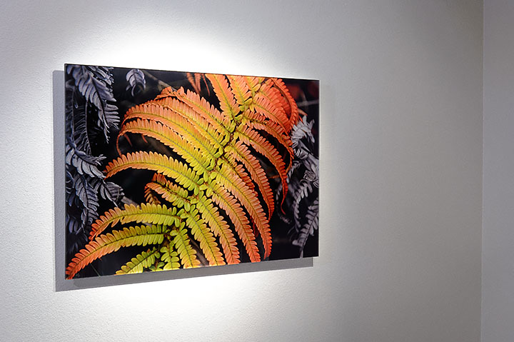
In past years, when I have arrived in southeast Alaska in late October/early November, it has been snowing with no sign of fall having ever occurred. But this year I was treated to a hint of what fall is like here with a few fall-colored leaves remaining on the trees and shrubs. I have been thinking about returning to southeast Alaska earlier next fall and this taste of fall has solidifying that idea.

Fall foliage along the Trail of Time near the Mendenhall Glacier. (John L. Dengler)

After the hike it was back to my motel to get ready for my early morning checkin at Auke Bay ferry terminal. When I say early, I mean a very early 3:45 a.m. check-in for the Alaska Marine Highway System ship, the M/V Malaspina; my transportation for the 4.5 hour trip up the Lynn Canal to my final destination of Haines.

The short peaceful hike was all that I needed after my two days of traveling to Juneau. I’m now ready for what I hope will be successful weeks filming bald eagles on the Chilkat River.

Moss covers the forest floor along the Trail of Time Trail near the Mendenhall Lake and Mendhenall Visitor Center just outside Juneau, Alaska. (© John L. Dengler/Dengler Images)


Be the first to know
‘Like’ the Dengler Images Facebook page
or ‘+1’ Dengler Images on Google+

to know when I post iPhone reports from the field.

Experience the ultimate in fine art presentation with acrylic face mount fine art prints

June 22, 2012 by John L. Dengler

acrylic face mount print, front

Photo Gallery

View fine art prints for sale

I’m incredibly excited about this acrylic face mount print that I ordered for myself – it almost jumps off the wall! Without question acrylic face mounted prints are the ultimate in photograph presentation. This 30″x20″ photo of an amau fern taken at Hawaii Volcanoes National Park on the Big Island of Hawaii has the look of a wet print. The simple borderless presentation is offset from the wall. These acrylic face mount fine art prints are ready to hang. When you consider the cost of matting and framing a large print, the initially more expensive acrylic face mount prints become more comparable.


READ MORE about acrylic face mount prints and other available print options on my fine art print information page.

Bald eagles and snow converge on the Chilkat River

February 26, 2012 by John L. Dengler

(Adobe Flash Slideshow – removed)

While it has snowed on all my trips to the Chilkat River to photograph bald eagles in Alaska, it never has REALLY snowed. The couple of inches of snow that I’ve previously experienced in November was nice, but not what you think of when you think Alaska snow. So as I clicked my seatbelt on the Alaska Airlines jet bound for Alaska, I made a silent wish for snow, lots of it.

It took me three days of traveling to reach my final destination of Haines where the Chilkat River empties into the fjord-like Lynn Canal. After overnight stays in Seattle and Juneau, I finally was in the Alaska Marine Highway System’s Auke Bay ferry terminal parking lot waiting to drive aboard the LeConte for the 4.5 hour passage to Haines.

After a crystal blue sky day spent at Mendenhall Glacier just outside Juneau, I sat in the pre-dawn darkness of the ferry terminal parking lot in what seemed like a blizzard. The wind was howling and snow was blasting horizontally but as I would later find out, this was nothing by Alaska standards.

I sailed on the LeConte three months earlier with my wife Carol, returning to Juneau after completing 14 days of photography by way of sea kayaking and wilderness camping in a remote region of Glacier Bay National Park and Preserve. On that return trip to Juneau we sat on the top deck of the LeConte in deck chairs, much like one would do on a cruise ship. It was so warm and sunny that one woman stripped down to her underwear to bask in the sun. Fast forward to November and no one is on the top deck except for myself and two small children who were having great time smacking each other with snowballs in the morning twilight.

Flying with the eagles

I reached Haines and got settled in with good friends Phyllis and Joanne at The Alaska Guardhouse, before meeting with Paul Swanstrom of Mountain Flying Service. Paul, an experienced Alaskan pilot, is a former wilderness guide who also worked in the photo department of a major Chicago-based corporation. Over the years he has flown some big name wildlife photographers (I’m not going to name drop, but its impressive). I felt his background in photography and as a highly skilled pilot was perfect for the aerial photography I needed to tell the story of bald eagles on the Chilkat River.

My primary goal was to take aerial photographs of the Tsirku River alluvial fan where the river meets the Chilkat River. It is here, in the Alaska Chilkat Bald Eagle Preserve, where a five mile stretch of the Chilkat River, known as the Chilkat Bald Eagle Council Grounds, that the largest congregation of eagles gather. Bald eagles come to this area because of the availability of spawned-out salmon and ice free water in late fall. The open water is due to a deep accumulation of gravel and sand that acts as a large water reservoir whose water temperature remains 10 to 20 degrees warmer than the surrounding water temperature. This warmer water seeps into the Chilkat River, keeping this five mile stretch of the river from freezing.

Paul and I looked over maps of the Chilkat River Valley and worked out a flight plan based on light at different times of day, needed altitude for the subject, etc.

Paul then introduced me to his plane, a spiffy fire engine red Bush Hawk-XP, which when I saw it, thought of it as the sports car of bush planes. I’d swear we were off the ground in less than 10 feet but know it took more runway. The plane allows Paul to add skis to the fat tundra tires for landings on snow or glaciers. Virtually, all of my aerial photography experience was as a newspaper photographer in St. Louis where all of it involved helicopters. I was a bit hesitate about shooting from a plane, but Paul rightfully convinced me that it would work.

I needed to meet with Paul right away because he had to begin taking his engine apart in two days to ship parts to the lower 48 for overhauling. If I was to fly, it would have to be either today (not happening – snowing), or tomorrow. The day after tomorrow his engine would be in pieces on the cold hanger floor.

As we shook hands and said goodbye, we both knew that it was almost certain that we would not be flying the following day. It was still snowing and the forecast looked very unfavorable for photography.

The following morning I began my ritual of photographing bald eagles (Haliaeetus leucocephalus) by being on the banks of the Chilkat River before sunrise. Sunrise in November is quite civil as it occurs quite a bit later than in the lower 48. As I made my way up the Haines Highway towards Canada in the advancing twilight, the heavily overcast skies were dripping with rain and snow — definitely not conducive to aerial photography and not a particularly comfortable day for photography on the river bank. I continued driving knowing that between Haines and the area where I photograph eagles there can be big differences in the weather. It can be raining cats and dogs in town and be bright and sunny up the river valley. I have met plenty of photographers who missed a great day of shooting because their decision not to head up the river was based on the weather in town.

After several hours of rain and a little snow, the skies opened up. There were patches of blue and I began to wonder if perhaps I might be able to fly. Conferring with Paul at this point wasn’t possible. I was a good 15 miles out of cell phone range. So I drove back down the Chilkat River Valley to a spot where I knew I would be able to call Paul. We both knew good light would still be a gamble with the rapidly changing nature of weather in Alaska but since today would be my sole chance of flying until next year, I decided it was worth a gamble.

I met Paul at his hanger at the Haines airport and we shot off the runway and into the neighboring Takhin River Valley to get into position for the Tsirku River delta. The weather was what I expected with portions of the flight having good light and others marginal with flat lighting. Paul maneuvered the Bush Hawk -XP perfectly into the shooting position we had earlier discussed. An unplanned bonus of the trip was jumping over the Takhinsha Mountains and looking down on McBride Glacier in Glacier Bay National Park and Preserve where I had kayaked in July. The mountains looked familiar, yet different now that they were blanketed in snow. The park seemed asleep, much like the Flint Hills tallgrass prairie in Kansas when I had visited there just a few weeks earlier. The Glacier Bay area is breathtakingly beautiful from the air. I always thought the best job in the world was that of a photojournalist. I still think that is true, but I now think that the second best job is that of a flight-seeing/charter pilot in Alaska. Paul is a lucky guy with one hell of an ‘office’ view.

Unusual sightings

On subsequent days, I stuck to my routine of being in place on the river early. The first stop I would make would be at the location where the bald eagle with white wing tips and talons was hanging out this year. This bald eagle is known as a leucistic bald eagle. Its white wing tips and talons are caused by a leucistic condition — a condition of reduced pigmentation resulting in white patches. These patches of white can occur while the rest of the animal is colored normally. Unlike albinism, the eye color is normal. Seeing this eagle was like seeing an old friend as I had photographed it several years earlier on the nearby Chilkoot River. The one thing I was surprised by watching this eagle was just how much, and often he ate. Since he stood out with his leucistic characteristics, it was easy to keep track of his meals. From watching bald eagles, I had the impression that eagles didn’t eat very often. For me, waiting for hours on end in the cold for action lasting no more than an eye blink, I would have guessed that 99% of their time was spent sitting on a tree branch or on the gravel bar taking bets amongst themselves on how long the crazy photographer would last. Considering the time I spent observing the white tipped eagle perhaps that is a false assumption.

Another unusual sight on this trip was when I saw a bald eagle drag a fish 15-20 feet up from the Chilkat River bank through the snow. Dragging a salmon that far of a distance is somewhat unusual as eagles usual drag a fish just barely out of the water onto the bank. Bald eagles are pretty dang lazy about putting out any effort to feed, particularly at this time of the year. What was more unusual was that the eagle dragged the fish right up to another eagle sitting on a log as if it wanted to share the salmon with the other bird. Normally, eagles challenge and fight each other. Formal sharing, is something I’ve never seen. In the end, the niceties didn’t last and the eagles were off trying to chase each other away. The winner in all this turned out to be a black-billed magpie who moved in and feasted on the fish while the two eagles chased each other in a circle.

(Adobe Flash Slideshow)

I’m always asked if I saw bears. I usually do, and often see their footprints in the fresh snow falls overnight. Along with the grizzly bear tracks I saw on this trip, I photographed an orphaned grizzly bear cub. The cub seemed to be enjoying life, but I knew what he didn’t know. That life was going to get very bad for him in the upcoming winter months and his survival was in question.

I missed a bit of excitement while I photographed eagles on another part of the river. Another photographer spotted a bald eagle whose wings were both frozen flat against the Chilkat River ice. An volunteer from the American Bald Eagle Foundation in Haines, slide out on the ice on her stomach and clipped the tips of the eagle’s feathers that were frozen to the river ice. The rescue was a success and the bird was expected to be back in the Alaskan skies after rehabilitation time at the Alaska Raptor Center in Sitka for feather mending. I would have liked to have witnessed the rescue and subsequent treatment.

Dealing with the snow

It seemed like it snowed every day, though in reality, there were several blue sky days. One day, we had a true blizzard, even by Alaskan standards, with building rattling, 50 mile per hour winds. In roughly 36 hours a total of 52 inches fell. That much snow, that early in November, was unusual. I’d say I got my wish for snow and then some.

The snow was very helpful for photography. Besides making the already incredible scenery more so, the blanket of snow did wonders for cleaning up extraneous visual noise in my bald eagle photos. Many of the bald eagles that I take photographs of are on visually cluttered gravel bars or river banks. The snow cleaned these shooting situations, almost like the eagles were shot in the studio on a white seamless background.

The only drawback to the heavy snowfall was that it made exploring a bit more difficult. One of my usual afternoon haunts is the Chilkoot River. I like to go to the Chilkoot in the afternoon as you’re on the opposite river bank from what you would be on the Chilkat avoiding the afternoon backlit light of the Chilkat River. With all the snow I wasn’t surprised this year to find the entrance to the Chilkoot Lake State Recreational Site and the Chilkoot River, to be completely blocked by snow. The only way in was going to be on foot with snowshoes.

A few days earlier, my friend Phyllis gave me some pointers on snowshoeing. Wanting to show me in the deepest snow possible, Phyllis with her dog Harry, drove me out in the direction of Chilkat State Park. The park is closed this time of the year so the road doesn’t get plowed. The snow was getting REALLY deep as Phyllis wrestled the car through the drifts. Eventually, the snow was too much and we were stuck. That meant it time for snowshoeing as we (and a very nervous Harry) waited for Joanne to come rescue us with her pickup truck. The snowshoes I used weren’t like the tennis racket ones you saw on the old TV series, Sergeant Preston of the Yukon. These were sleek, lightweight aluminum ones. For the rest of the trip, I would use them whenever I would go off the beaten path. I found them particularly useful for going up and down steep riverbanks. Many of these riverbanks would have been difficult to climb without the deep snow. The snow, and the snowshoes, made climbing them with my large tripod, 600 mm lens, and heavy cameras, much easier. The only bad thing was I was always breaking a trail since I was usually by myself on these treks. In deep snow, even with snowshoes, hiking can be taxing. The trips back were always much easier as I would backtrack over my path. Snowshoes are great!

I’ve written in the past about taking a small camping sleeping mat to stand on to keep my feet warm while standing in the snow. Having the mat on this trip proved to be even more important with all the snow; as you can see in this photo of one of the spots where I photographed the bald eagles.

Technical tips

For the past year, I’ve been shooting using manual aperture and shutter speed with auto ISO as my exposure setting. I really like this mode and it allows me to be in control of the appropriate aperture and shutter speed letting the ISO setting be the variable. For consumer DSLR cameras that could be a problem as the ISO creeps up, but with a professional DSLR like my Nikon D3 that isn’t an issue. Considering my positive experience this past year with this configuration I’m likely to use this setting in the future.

I’m assuming that you’ve watched the slideshow at the top of this posting of images from this trip. It may seem like there aren’t as many images from previous trips. This is because I have become more selective, and do not want to put duplicate situations into my photo archive. I’ve even eliminated previous archive images with new work that I feel is stronger. I like to think that this means that my work is improving and evolving.

Speaking of evolving, I shot video for a few hours. I didn’t get anything special (you can see the video here), but wanted to see what challenges shooting video here would be. I plan to work on this during future visits to Alaska.

By the time I left Alaska a total of 88 inches of snow had fallen in the Haines area. I know my Alaska friends in Haines have had their fill of snow by now, but I’m thankful that my wish for snow came true.


ABOVE: Slideshows require Adobe Flash.

For more photos see:
Gallery of bald eagle photos from the Chilkat River and Chilkoot River
Gallery of landscape photos from the Haines, Alaska area
Gallery of photos from the Juneau, Alaska area
Gallery of photos from Glacier Bay National Park and Preserve

Golden hour at the Tallgrass Prairie National Preserve

December 18, 2011 by John L. Dengler

The Lower Fox Creek Schoolhouse and a lone cottonwood tree are silhouetted against a dramatic fall sunrise at the Tallgrass Prairie National Preserve. The 10,894-acre Tallgrass Prairie National Preserve is located in the Flint Hills of Kansas in Chase County near the towns of Strong City and Cottonwood Falls. Less than four percent of the original 140 million acres of tallgrass prairie remains in North America. Most of the remaining tallgrass prairie is in the Flint Hills in Kansas. Tallgrass Prairie National Preserve is the only unit of the National Park Service dedicated to the preservation of the tallgrass prairie ecosystem. The Tallgrass Prairie National Preserve is co-managed with The Nature Conservancy. (John L. Dengler)

My October visit to the Tallgrass Prairie National Preserve in the Flint Hills of Kansas did not disappoint. The prairie was ablaze in the colors of fall and some of the early dawn skies were spectacular displays of clouds and sky that appeared to be on fire; reminiscent of the flames of the nighttime prescribed burning of the prairie I witnessed in April.

These pre-sunrise displays of color are often referred to by photographers as the golden or magic hour. It’s really not an hour per say and the golden hour also refers to the evening sky just after the sun has set. The moment of optimum color can be a fleeting few seconds or it can last for hours. The key is that if the sun is visible on the horizon in the morning, chances are you have missed the best display and if the sun is still on the horizon in the evening, the best is yet to come. The early dawn photos of the Lower Fox Creek School at the Tallgrass Prairie National Preserve are a prime example.

Photo Gallery

Images from fall trip to the tallgrass prairie

Anyone who studies the photos of National Geographic photographers will see that many of their outdoor photographs are taken in the very early morning hours and in the fading light of the early evening. National Geographic photographers know this and plan their day accordingly, shooting interiors, traveling, etc. during midday.

Spectacular pre-dawn photos come at a price — sleep. If you’re not hiking to your location in the dark (and by dark, I mean having to use headlamps), chances are you’re going to miss the magic light. If the sun is already above the horizon, you might as well go back to bed. On countless mornings I have had to force myself out of the warmth and comfort of my sleeping bag to head out in the darkness and on countless evenings have had to return to camp to make dinner in the dark. On a few occasions when I was car camping I would have to move the entrance barrier to the campground to exit in those early hours. Neighboring campers would wonder if I even existed as I was never seen.

A lot of photography is about luck, and by luck I don’t mean just being lucky. You need to make your luck. Research is probably the most important secret to a good photograph. Knowing when, where, and why will always increase your luck. It’s like buying a thousand lottery tickets instead of just one. To help make my luck I use several iPhone and computer apps that will show me precisely where and when the sun and moon will rise and set, their position through the day for shadows, where the Milky Way will be, and what approaching cloud cover (or lack of) will be. I’ll even use 3D mapping programs with satellite imaging to give me a feel for what I might see.

If you look at the photos in the slideshow, you’ll notice that many of the images might seem redundant. As a stock image photographer, I need to keep the needs of a designer in mind. For example, there are multiple images of the Lower Fox Creek School silhouetted in the pre-dawn light. No, it’s not a case of I can’t make up my mind which photo I like better, but rather there are multiple images to give designers choices. Would a page design work better with the school on the left, or the right? In addition, I’ve left plenty of space for story or cover text. I’ve also included vertical and horizontal options. These examples of shooting with possible design usage in mind are all things that I looked for when I was a magazine art director/designer and bought usage licenses. Here again, I’m making luck that hopefully will result in a licensing sale.

The tallgrass prairie in the Flint Hills takes on a whole new personality in the fall. Grasses and wildflowers turn brown and red after the first chill of fall and the incessant frantic calling of dickcissels are replaced with the quieter chirps of crickets. It’s like the prairie knows that it is time to rest. The tallgrass prairie simply feels calm and quiet, just like the drowsiness a person feels just before falling to sleep. I’m looking forward to traveling back to the Flint Hills in the weeks ahead to walk the sleeping prairie as it is blanketed in snow.


ABOVE: The Lower Fox Creek Schoolhouse and a lone cottonwood tree are silhouetted against a dramatic fall sunrise at the Tallgrass Prairie National Preserve. The 10,894-acre Tallgrass Prairie National Preserve is located in the Flint Hills of Kansas in Chase County near the towns of Strong City and Cottonwood Falls. Less than four percent of the original 140 million acres of tallgrass prairie remains in North America. Most of the remaining tallgrass prairie is in the Flint Hills in Kansas. Tallgrass Prairie National Preserve is the only unit of the National Park Service dedicated to the preservation of the tallgrass prairie ecosystem. The Tallgrass Prairie National Preserve is co-managed with The Nature Conservancy.

To license image, click image. To see our collection of fine art prints, click here.

« Previous Page
Next Page »

Search this blog

Follow Me

  • Email
  • Facebook
  • Instagram
  • RSS
  • Vimeo

Recent Dispatches

  • Recent landslide-triggered tsunami brings back memories
  • Nature’s Window: Snowy, quiet day in Haines
  • Channeling Bradford Washburn
  • Haines Winterfest equals winter fun
  • Prairie chicken photos published by North American Grouse Partnership
  • Springtime at Devil’s Den
  • Sharp-tailed grouse video published by Audubon Magazine
  • Black and White – only because I felt like it

Blog Category Topics

  • Books
  • Environment
  • Fauna
  • Featured
  • Fine art prints
  • Flora
  • Gear
  • iPhone Field Reports
  • Landscapes
  • Latest Dispatches
  • Note cards
  • Passions
  • Personal
  • Photojournalism
  • Recreation
  • Research
  • Sports
  • Tearsheets
  • Techniques
  • Travel
  • Videos
  • Wildlife

New archive images

Gallery of new outdoor photos added to photo archive

Contact

Phone:
+1.417.849.5642
Email:
studio@denglerimages.com

Copyright Information

All photographs and text within DenglerImages.com are copyright John L. Dengler and/or the stated publication and are presented for web browser viewing only. Nothing contained within this site may be reproduced, downloaded, stored, copied, manipulated, altered, or used in any form without prior written permission from John L. Dengler and/or the stated publication. Do not "pin" images on pinning sites (Pinterest, Tumblr, etc.). Using any image as the base for another illustration or graphic content, including photography, is a violation of copyright and intellectual property laws. Violation of copyright will be actively prosecuted.

Newsletter signup

Sign up for our free email newsletter to keep updated on recent work, new products, or coupon specials. Simply enter your details, and confirm your address with the confirmation email that we send. It's easy and safe. We never share our newsletter list.

CLICK HERE to sign-up to receive newsletter and new blog post alerts.

Dengler Images, LLC specializes in stock image licensing of photos of wildlife, nature, landscape,
outdoor sports and recreation, travel, and our environment.

© 2008-2025 John L. Dengler, Dengler Images, LLC - All rights reserved.