Dengler Images

  • Portfolio
    • Portfolio Book
    • Sample Images
  • Archive
  • Blog
  • Store
    • Licensing
    • Prints
    • Note cards
    • Books
  • About
    • Bio
    • Services
    • Newsletter Signup
    • Instagram
    • Copyright
    • Privacy Policy
  • Contact

Grizzly bear saliva collection research project update

November 12, 2016 by John L. Dengler

Rachel Wheat, a graduate student at the University of California Santa Cruz, takes a bear saliva DNA sample from a partially consumed salmon on the banks of the man-made spawning channel of Herman Creek, near Haines, Alaska. Wheat is collecting DNA samples of bears from bear saliva left on salmon carcasses as part of research for her doctoral dissertation. She hopes to determine if partially-consumed salmon carcasses can serve as a viable source for bear DNA to genotype individuals. She also looking to determine a minimum population estimate for the number of bears using the Chilkoot Valley and the ratio of males to females, particularly in light of increase human presence. The bear DNA collection is part of her dissertation which looks at how the availability of salmon affects eagle movement, bear activity, and subsistence fishermen. EDITORS NOTE: Images of Wheat capturing bald eagles for the bald eagle portion of her study are available here: http://denglerimages.photoshelter.com/gallery/Bald-eagle-research-Chilkat-River-eagle-migration-study/G0000GTyPvah7eiQ/ During late fall, bald eagles congregate along the Chilkat River to feed on salmon. This gathering of bald eagles in the Alaska Chilkat Bald Eagle Preserve is believed to be one of the largest gatherings of bald eagles in the world. (© John L. Dengler/Dengler Images)

Remember when I photographed the ecologist collecting grizzly bear saliva DNA left on partially-consumed salmon carcasses? Well, Dr. Rachel Wheat recently had her findings from that research project published. Wheat’s research found collecting salivary environmental DNA (eDNA) in this noninvasive manner is effective in results, time in the field and cost over other methods like having to trap a bear. Wheat believes this research will be useful in studying population densities, movement and feeding behavior.

Photo Gallery

Images of Wheat collecting bear saliva for DNA

The research and methodology is interesting. Read her paper, Environmental DNA from Residual Saliva for Efficient Noninvasive Genetic Monitoring of Brown Bears (Ursus arctos) for details.

If you missed it, check out my original blog post and photos of her project, Collecting DNA samples from grizzly bear saliva, SAY WHAT?

Congratulations Rachel!

LINKS

  • LEARN MORE — Wheat’s research projects in Haines, Alaska on her blog, Ecology Alaska
  • PHOTO GALLERY — Wheat capturing bald eagles on the Chilkat River in Alaska for migration study

To license image, click image. To see our collection of fine art prints, click here.

Massive landslide pours onto Lamplugh Glacier

July 23, 2016 by John L. Dengler

A 4,000-foot-high mountainside released approximately 120 million metric tons of rock in 60 seconds during a landslide onto the Lamplugh Glacier in Glacier Bay National Park and Preserve. In an interview with the Alaska Dispatch News, geophysicist Colin Stark of Columbia University's Lamont-Doherty Earth Observatory, described the slide as “exceptionally large.” He compared the massive landslide to roughly 60 million medium SUVs tumbling down a mountainside. The slide occurred on the morning of June 28 in a remote area of Glacier Bay National Park in southeast Alaska. It was first observed by Paul Swanstrom, pilot and owner of Haines-based Mountain Flying Service. Swanstrom noticed a huge cloud of dust over the Lamplugh Glacier during a flightseeing tour of Glacier Bay National Park several hours after the slide occurred. Swanstrom estimates the debris field to be 6.5 miles long, and one to two miles in width. Even two days later, as this aerial photo of the Lamplugh Glacier landslide shows, a dust cloud remained over the unstable mountainside due to still tumbling rock. (© John L. Dengler/Dengler Images)

I was fortunate to be in Haines, Alaska when a massive landslide occurred on the Lamplugh Glacier in nearby Glacier Bay National Park and Preserve. The slide occurred on the morning of June 28 in a remote area of Glacier Bay National Park in southeast Alaska. The landslide was first observed by Paul Swanstrom, pilot and owner of Haines-based Mountain Flying Service. During a flightseeing tour of Glacier Bay National Park, Paul noticed a huge cloud of dust over the Lamplugh Glacier several hours after the slide occurred. He investigated the source and found a mountainside missing with a debris field 6.5 miles long, and one to two miles in width.

Photo Gallery

Additional images of the Lamplugh Glacier landslide

Two days later, I had the opportunity to survey the destruction first hand. It is hard to fathom how half of a mountain could simply disappear by spilling itself onto the glacier. The 4,000-foot-high mountainside released approximately 120 million metric tons of rock in 60 seconds during a landslide onto the Lamplugh Glacier. In an interview with the Alaska Dispatch News, geophysicist Colin Stark of Columbia University’s Lamont-Doherty Earth Observatory described the slide as “exceptionally large.” He compared the massive landslide to roughly 60 million medium SUVs tumbling down a mountainside. Yes, that’s what he said. 60 MILLION SUVs careening down a mountainside, all at once.

There were several geologists on the plane with me who also wanted a closer look. Paul skillfully piloted his de Havilland Beaver close to the top ridge of the slide.

A 4,000-foot-high mountainside released approximately 120 million metric tons of rock in 60 seconds during a landslide onto the Lamplugh Glacier in Glacier Bay National Park and Preserve. In an interview with the Alaska Dispatch News, geophysicist Colin Stark of Columbia University's Lamont-Doherty Earth Observatory, described the slide as “exceptionally large.” He compared the massive landslide to roughly 60 million medium SUVs tumbling down a mountainside. The slide occurred on the morning of June 28 in a remote area of Glacier Bay National Park in southeast Alaska. It was first observed by Paul Swanstrom, pilot and owner of Haines-based Mountain Flying Service. Swanstrom noticed a huge cloud of dust over the Lamplugh Glacier during a flightseeing tour of Glacier Bay National Park several hours after the slide occurred. Swanstrom estimates the debris field to be 6.5 miles long, and one to two miles in width. Even two days later, as this aerial photo of the Lamplugh Glacier landslide shows, a dust cloud remained over the unstable mountainside due to still tumbling rock. (© John L. Dengler/Dengler Images)

Boulders were still tumbling down the unstable mountainside as we circled the ridge, adding to the dust cloud still hanging over the Lamplugh Glacier. Even the geologists aboard were amazed at the power of what we saw. In an interview with Haines public radio station KHNS, Micheal West, director of the Alaska Earthquake Center at the University of Alaska Fairbanks said that the vibrations, equivalent to about a magnitude-5.5 earthquake, were picked up as far away as Barrow and Nome. Scientists say that tectonic plate activity and eroding glaciers are often the cause of such landslides. As glaciers melt, mountainsides no longer receive the buttressing support afforded by a glacier.

Landslides are not uncommon is this geologically active region. While most are smaller, last fall in Alaska’s remote Taan Fiord of Icy Bay, a similar-sized landslide produced a wave that took down trees more than 500 feet up the opposite mountainside.

Think about this. A wave of water crashing up the opposite mountainside of a bay to a height almost as tall as the Gateway Arch in St. Louis, stripping the forested mountainside to bare rock. I guess it is nature’s version of a belly flop into a swimming pool.

A 4,000-foot-high mountainside released approximately 120 million metric tons of rock in 60 seconds during a landslide onto the Lamplugh Glacier in Glacier Bay National Park and Preserve. In an interview with the Alaska Dispatch News, geophysicist Colin Stark of Columbia University's Lamont-Doherty Earth Observatory, described the slide as “exceptionally large.” He compared the massive landslide to roughly 60 million medium SUVs tumbling down a mountainside. The slide occurred on the morning of June 28 in a remote area of Glacier Bay National Park in southeast Alaska. It was first observed by Paul Swanstrom, pilot and owner of Haines-based Mountain Flying Service. Swanstrom noticed a huge cloud of dust over the Lamplugh Glacier during a flightseeing tour of Glacier Bay National Park several hours after the slide occurred. Swanstrom estimates the debris field to be 6.5 miles long, and one to two miles in width. Even two days later, as this aerial photo of the Lamplugh Glacier landslide shows, a dust cloud remained over the unstable mountainside due to still tumbling rock. (© John L. Dengler/Dengler Images)

A 4,000-foot-high mountainside released approximately 120 million metric tons of rock in 60 seconds during a landslide onto the Lamplugh Glacier in Glacier Bay National Park and Preserve. In an interview with the Alaska Dispatch News, geophysicist Colin Stark of Columbia University's Lamont-Doherty Earth Observatory, described the slide as “exceptionally large.” He compared the massive landslide to roughly 60 million medium SUVs tumbling down a mountainside. The slide occurred on the morning of June 28 in a remote area of Glacier Bay National Park in southeast Alaska. It was first observed by Paul Swanstrom, pilot and owner of Haines-based Mountain Flying Service. Swanstrom noticed a huge cloud of dust over the Lamplugh Glacier during a flightseeing tour of Glacier Bay National Park several hours after the slide occurred. Swanstrom estimates the debris field to be 6.5 miles long, and one to two miles in width. Even two days later, as this aerial photo of the Lamplugh Glacier landslide shows, a dust cloud remained over the unstable mountainside due to still tumbling rock. (© John L. Dengler/Dengler Images)

A 4,000-foot-high mountainside released approximately 120 million metric tons of rock in 60 seconds during a landslide onto the Lamplugh Glacier in Glacier Bay National Park and Preserve. In an interview with the Alaska Dispatch News, geophysicist Colin Stark of Columbia University's Lamont-Doherty Earth Observatory, described the slide as “exceptionally large.” He compared the massive landslide to roughly 60 million medium SUVs tumbling down a mountainside. The slide occurred on the morning of June 28 in a remote area of Glacier Bay National Park in southeast Alaska. It was first observed by Paul Swanstrom, pilot and owner of Haines-based Mountain Flying Service. Swanstrom noticed a huge cloud of dust over the Lamplugh Glacier during a flightseeing tour of Glacier Bay National Park several hours after the slide occurred. Swanstrom estimates the debris field to be 6.5 miles long, and one to two miles in width. This aerial photo of the Lamplugh Glacier landslide was taken two days after the landslide. (© John L. Dengler/Dengler Images)


To license image, click image. To see our collection of fine art prints, click here.

Constantine Metal Resources proposes to extend access road to Palmer Deposit Project

December 16, 2015 by John L. Dengler

In August 2015, Constantine Metal Resources Ltd. of Vancouver, British Columbia submitted a plan with the Bureau of Land Management to extend their existing access road by 2.5 miles including a switchback road leading to a staging area for equipment and facilities at the 800 ft. level on the side of the approximate 1,700 ft. high mountainside. A proposed bridge crossing Glacier Creek would be located in the shadow area on the left side the photo with a switchback road leading from the Glacier Creek to the staging area for helicopter and ground-supported activities. The road would also provide access for up to 40 new exploration drill sites.Constantine Metal Resources along with investment partner Dowa Metals & Mining Co., Ltd. of Japan is exploring a potential site for a mine on the steep mountain slopes pictured above Glacier Creek. This area above Glacier Greek near Mount Henry Clay, known as the Palmer Deposit, is located near mile 40 of the Haines Highway. Constantine Metals Resources says they plant to continue the exploration phase of their projects for the next five to 10 years.(© John L. Dengler/Dengler Images)

In August 2015, Constantine Metal Resources Ltd. of Vancouver, British Columbia submitted a plan with the Bureau of Land Management to extend their existing access road by 2.5 miles including a switchback road leading to a staging area for equipment and facilities at the 800 ft. level on the side of the approximate 1,700 ft. high mountainside. In the photo above, a proposed bridge crossing Glacier Creek would be located in the shadow area on the left side the photo with a switchback road leading from the Glacier Creek bridge to the staging area for helicopter and ground-supported activities. The road would also provide access for up to 40 new exploration drill sites.

Aerial map

How proposed road would appear on above photo

The road extension project requires Contantine Metal Resources to submit a new plan due to that their proposal puts Constantine Metal Resources beyond the current limits of their current permit for five acres of ground disturbance. The new proposal requires public, stakeholder, and agency review, including a National Environmental Policy Act Analysis.

Constantine Metal Resources along with investment partner Dowa Metals & Mining Co., Ltd. of Japan is exploring a potential site for a mine on the steep mountain slopes pictured above Glacier Creek. This area above Glacier Greek near Mount Henry Clay, known as the Palmer Deposit, is located near mile 40 of the Haines Highway. Constantine Metals Resources says they plant to continue the exploration phase of their projects for the next five to 10 years.

The minerals that Constantine’s drilling explorations have found are primarily copper and zinc, with significant amounts of gold and silver. Exploratory drilling to refine the location and mineral amounts are the current focus of the company.

If approved and developed, the mine, near Haines, Alaska would be an underground mine. Besides the actual ore deposits, having the nearby highway access for transporting ore to the deepwater port at Haines is also attractive to Constantine.

Support for a large scale mine such as the Constantine project is divided among residents of Haines, a small community in Southeast Alaska 75 miles northwest of Juneau. The community’s needed economic boost from jobs, development and other mine support that a large-scale mine brings is tempting to some. To others, anything that might put the salmon spawning and rearing habitat and watershed resources at risk is simply unimaginable and unacceptable. Of particular concern is copper and other heavy metals in mine waste leaching into the Klehini River and the Chilkat River 14 miles downstream. Copper and heavy metals are toxic to salmon and bald eagles.

The Chilkat River chum salmon are the primary food source for one of the largest gatherings of bald eagles in the world. Each fall, bald eagles congregate in the Alaska Chilkat Bald Eagle Preserve, located only three miles downriver from the area of current exploration.

In August 2015, Constantine Metal Resources Ltd. of Vancouver, British Columbia submitted a plan with the Bureau of Land Management to extend their existing access road by 2.5 miles including a switchback road leading to a staging area for equipment and facilities at the 800 ft. level on the side of the approximate 1,700 ft. high mountainside. A proposed bridge crossing Glacier Creek would be located in the shadow area in the lower center of the photo with a switchback road leading from the Glacier Creek to the staging area for helicopter and ground-supported activities on the left. The road would also provide access for up to 40 new exploration drill sites. Pictured at the top of the photo is the Klehini River. A map showing exactly how this road would appear can be found here: https://eplanning.blm.gov/epl-front-office/projects/nepa/54990/65845/71485/Figure_6.4_accessible.pdf Constantine Metal Resources along with investment partner Dowa Metals & Mining Co., Ltd. of Japan is exploring a potential site for a mine on the steep mountain slopes pictured above Glacier Creek. This area above Glacier Greek near Mount Henry Clay, known as the Palmer Deposit, is located near mile 40 of the Haines Highway. Constantine Metals Resources says they plant to continue the exploration phase of their projects for the next five to 10 years. The minerals that Constantine’s drilling explorations have found are primarily copper and zinc, with significant amounts of gold and silver. Exploratory drilling to refine the location and mineral amounts are the current focus of the company. If approved and developed, the mine, near Haines, Alaska would be an underground mine. Besides the actual ore deposits, having the nearby highway access for transporting ore to the deepwater port at Haines is also attractive to Constantine. Support for a large scale mine such as the Constantine project is divided among residents of Haines, a small community in Southeast Alaska 75 miles northwest o (© John L. Dengler/Dengler Images)

A proposed bridge crossing Glacier Creek would be located in the shadow area in the lower center of the photo above with a switchback road leading from the Glacier Creek to the staging area for helicopter and ground-supported activities on the left mountain slope. Pictured in the background is the nearby Klehini River (visible) and Haines Highway (not visible).

LINKS

  • PHOTO GALLERY – Photos of Constantine Metals Palmer Project area of exploration
  • ROAD EXPLORATION PROJECT SUMMARY to Bureau of Land Management
  • CONSTANTINE METAL RESOURCES LTD. – Palmer Project
  • HIGH COUNTRY NEWS – Could an Alaska mining project jeopardize Earth’s largest bald eagle gathering?

To license image, click image. To see our collection of fine art prints, click here.

Dengler Images blog referenced in Haines Highway environmental assessment

October 14, 2015 by John L. Dengler

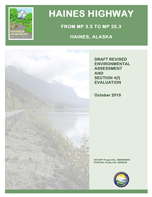
Haines Highway revised environmental assessment cover

This morning, I was skimming through the 382 page Draft Revised Environmental Assessment and Section Evaluation – October 2015 on proposed improvements to the Haines Highway near Haines, Alaska when out popped my name.

DOT Revised Environmental Assessment

Haines Highway Draft Revised Environmental Assessment and Section Evaluation – October 2015

I was surprised to see my blog posting on the ongoing exploration at the Constantine Metal Resources’ Palmer Deposit mine project referenced in the document by the Alaska and U.S. Departments of Transportation. I don’t think my work has been referenced in an environmental assessment before. You never know where your name or work will pop up.

LINKS

  • My original blog posting: Constantine Metal Resources’ Palmer Deposit Mine project
  • I later also posted this update: Bald eagle’s view of the Palmer Deposit
  • Finally here is a link to a blog post that I did on the Haines Highway project proposal: Haines Highway realignment — balancing safety and the environment
« Previous Page
Next Page »

Search this blog

Follow Me

  • Email
  • Facebook
  • Instagram
  • RSS
  • Vimeo

Recent Dispatches

  • Recent landslide-triggered tsunami brings back memories
  • Nature’s Window: Snowy, quiet day in Haines
  • Channeling Bradford Washburn
  • Haines Winterfest equals winter fun
  • Prairie chicken photos published by North American Grouse Partnership
  • Springtime at Devil’s Den
  • Sharp-tailed grouse video published by Audubon Magazine
  • Black and White – only because I felt like it

Blog Category Topics

  • Books
  • Environment
  • Fauna
  • Featured
  • Fine art prints
  • Flora
  • Gear
  • iPhone Field Reports
  • Landscapes
  • Latest Dispatches
  • Note cards
  • Passions
  • Personal
  • Photojournalism
  • Recreation
  • Research
  • Sports
  • Tearsheets
  • Techniques
  • Travel
  • Videos
  • Wildlife

New archive images

Gallery of new outdoor photos added to photo archive

Contact

Phone:
+1.417.849.5642
Email:
[email protected]

Copyright Information

All photographs and text within DenglerImages.com are copyright John L. Dengler and/or the stated publication and are presented for web browser viewing only. Nothing contained within this site may be reproduced, downloaded, stored, copied, manipulated, altered, or used in any form without prior written permission from John L. Dengler and/or the stated publication. Do not "pin" images on pinning sites (Pinterest, Tumblr, etc.). Using any image as the base for another illustration or graphic content, including photography, is a violation of copyright and intellectual property laws. Violation of copyright will be actively prosecuted.

Newsletter signup

Sign up for our free email newsletter to keep updated on recent work, new products, or coupon specials. Simply enter your details, and confirm your address with the confirmation email that we send. It's easy and safe. We never share our newsletter list.

CLICK HERE to sign-up to receive newsletter and new blog post alerts.

Dengler Images, LLC specializes in stock image licensing of photos of wildlife, nature, landscape,
outdoor sports and recreation, travel, and our environment.

© 2008-2025 John L. Dengler, Dengler Images, LLC - All rights reserved.